


Scientists discussed ways to predict dangerous natural phenomena and disasters
We are still sitting on a powder keg — about a hundred natural disasters occur in Russia every year, which result in loss of housing and death for residents or diseases. Meanwhile, it turns out that scientists know how to properly “tame” floods and even predict strong earthquakes 2–7 days before a disaster. The main thing is that the authorities hear them.
At the Laverov Readings-2024 conference at the Russian Academy of Sciences held on the eve of Science Day, Russian scientists demonstrated knowledge of the nature of cataclysms and determination to resist them.
Let's start with the ecology of Moscow. The president of the Faculty of Geography of Moscow State University spoke about the latest data on atmospheric aerosols, road dust and river waters. Lomonosov Academician of the Russian Academy of Sciences Nikolai Kasimov.
He noted that, despite the closure or removal of industrial enterprises outside the metropolis, there are still more than 1.5 thousand small industrial and non-industrial diffuse sources of pollution.
The scientist identified the main elements of the periodic table that are concentrated in road dust, for example, in the more industrial Eastern Moscow, these are antimony and cadmium, and in Western Moscow, where transport contributes a larger share of pollution, lead and zinc.
By the way, as for lead, or more precisely, its compounds from volatile gasoline vapors, which quite recently spoiled the air of Muscovites, they, according to Nikolai Sergeevich, ceased to dominate the city as a whole, falling among the most accumulating elements to 4–5th place . This happened in connection with the introduction of the environmental standard for Euro-5 fuel in Moscow. But other sources of air pollution, to which experts previously did not pay much attention, came to the forefront: these are abrasive car pads, tires, curbs, and the asphalt surface itself. In the Eastern District, according to the scientist, there is nothing special, but, for example, at the site of the long-defunct Serp and Molot plant on Entuziastov Highway there is quite a lot of dust — serious anomalies are still being discovered there.
Kasimov notes that environmentalists have appreciated the large contribution of road dust to urban air pollution. This is primarily characteristic of the Western District. The main sources of dust here are the Moscow Ring Road and courtyards with parking lots.
Another important note: both road dust and aerosols have a single association of chemical elements. And what influences what more is unclear. Apparently, it is still road dust, because there is more of it by mass than aerosol. And it is very important that the maximum accumulation occurs in the smallest particles ranging in size from 1 to 10 microns, which need to be analyzed during environmental monitoring.
It is dust that becomes a source of pollution of urban rivers, as shown by more detailed studies in the Setun River basin, the right tributary of the Moskva River in the west of Moscow and in the Moscow region. If previously they measured mainly the dissolved phase of substances in water, then in order to understand this phenomenon, it is necessary to measure the content of chemical elements not only in dissolved form, but also in suspension, that is, in dust particles in water.
Last year, geographers from Moscow State University for the first time studied a completely new, but no less significant source of air pollution for Moscow—railway dust. Dressed in orange vests, scientists took its samples at the Kievsky and Leningradsky railway stations.
“Such railway dust differs significantly in the presence of metal components,” Kasimov explained to the MK observer. — These components appear as a result of rail abrasion. One of the distinctive components of railway dust is molybdenum, which is quite toxic to plants.
— It is important to note that Moscow, in principle, is a clean city. Yes, we have many problems — chemical elements and organic pollution accumulate in various components of the urban environment, but still, when you compare the city according to some indicators, for example, road dust, with other cities, it turns out that we have not so bad yet. There is not a single element that we would have more of than, for example, in Tehran, Beijing, and European cities. The same situation applies to aerosols. We have an average European level, like in Paris, Vienna or Warsaw. It is very important that gas heating, which is more environmentally friendly than coal, helps us maintain the eco-balance.
Let's get off the ground and look at dangerous natural phenomena from space. The scientific director of the Research Institute of Aerospace Monitoring «Aerospace», Academician of the Russian Academy of Sciences Valery Bondur singles out natural fires and floods among all the natural disasters that cause the greatest damage to Russia.
— Among emergency situations, there are, of course, man-made ones. But it is natural disasters that cause the greatest material damage,” says the MK academician. — On the territory of our country they make up more than 90 percent!
Let's talk about wildfires. Now winter is a time of some calm, when we can carry out technical work with the monitoring system, but as soon as spring begins, fires will begin. As usual, from March-April, agricultural burns grow — burning of last year's dry grass, which often turns into fires, including forest fires. When there are still few leaves, as a rule, dry trees burn, and then, with the appearance of leaves, emissions of trace gas components into the atmosphere increase, including carbon dioxide and carbon monoxide, methane, nitrogen oxides and other substances, as well as fine aerosols that are harmful to human health and influencing the planet's climate.
— Our system can prevent the dangerous spread of fire. For example, we previously worked closely in this direction with electric grid companies that were responsible for the operation of main power lines and electrical substations. It is very important that high-intensity fires do not spread into the buffer zone of such objects. Our system of space monitoring of natural fires in an operational mode ensured early detection of their sources. As soon as the fire fell into the buffer zone, which was located 25 kilometers from the main power lines or electrical substations, information about this event, generated from space data, was immediately delivered to the customer’s information center. If the intensity of the fire entering such a buffer zone reached a high level (category 5), then it was necessary to disconnect the corresponding main power line. This prevented catastrophic events associated with accidents at such critical infrastructure facilities, which could cause enormous damage.
Unfortunately, we currently do not monitor electric power facilities—we do not have joint agreements. Currently, the results of satellite monitoring of natural fires and their consequences obtained by our organization are used to solve other problems, including studying the impact of fires and related consequences on climate change, on the processes of deforestation, reforestation, etc., that is, mainly for scientific purposes. Just imagine — to solve such problems, we have already systematized and processed more than 6.6 million (!) space images.
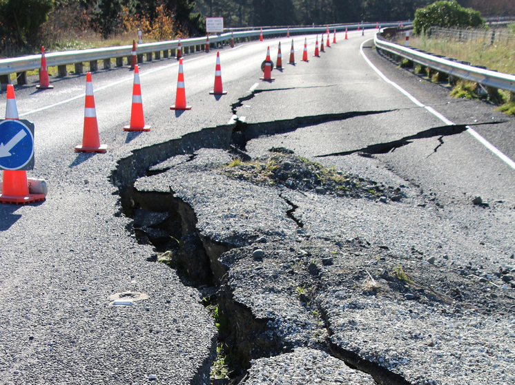
But we can also bring real benefits with the help of satellites. In addition to preventing the spread of natural fires, we monitor other types of dangerous natural phenomena and disasters, such as typhoons, floods, landslides, volcanic eruptions, abnormal anthropogenic and natural biogenic pollution of the water environment and many others. We conduct scientific research in the interests of medium-term and even short-term forecasting of strong earthquakes with magnitudes greater than 6.
“Today, of the existing methods for predicting earthquakes, the most reliable are only long-term ones, which can predict high seismic activity in a particular region several years in advance. But as we approach hour X, over intervals of several months and, even more so, days, the probability of the forecast decreases significantly, and satellite methods can fill this niche.
We are still developing satellite methods for monitoring seismic-prone areas, exploring past earthquakes. We have developed methods for recording from space the precursors of strong earthquakes (with a magnitude greater than 6), manifested in anomalies of various geophysical fields (geodynamic, ionospheric, thermal, etc.) that arise during the preparation and occurrence of seismic events.
To register these anomalies during an increase in seismic activity, special technical means and systems are required. It's not easy to create them. Therefore, scientific ingenuity is needed. For example, to register anomalous variations in ionospheric parameters when monitoring seismically hazardous areas, scientists proposed using data generated by global navigation satellite systems. With their help, it is already possible today to monitor ionospheric parameters over seismically hazardous areas and register short-term ionospheric precursors of earthquakes. And for this, no additional complex “hardware” needs to be created.
— At one time, we worked with American colleagues and carried out space monitoring of earthquake-prone regions in California. We were able to predict several earthquakes 7 to 2 days before they started. Our American colleagues wanted us to monitor earthquake-prone areas throughout the United States, but politics took us in different directions.
In the field of methods and technologies for recording from space the harbingers of strong earthquakes, as well as other dangerous natural phenomena and disasters, we are ahead of our foreign colleagues, but, alas, we are behind in terms of technical means: we have few remote sensing satellites of our own. This is the most serious problem. It is necessary, firstly, to radically increase the domestic satellite constellation. Secondly, it is necessary to create a new type of remote sensing equipment. First of all, these are synthetic aperture radars (active side-scanning remote sensing sensors placed on board an aircraft). They can receive data about various objects and phenomena under study on Earth, despite cloudiness, in polar night conditions, etc. Third, we need methods for processing and storing large streams of remote sensing data, the volumes of which will reach 300 exabytes in 2025 (1 exabyte is 1018 bytes).
There are currently 6,800 active satellites in space. Our share is less than 150, there are very few remote sensing satellites. Foreign constellations are also being intensively replenished with small spacecraft, which very soon will “look” at the Earth almost continuously, with high spatial resolution.
— There is an idea to create a multi-satellite remote sensing system based on small spacecraft weighing about 100 kg. They will be able to observe the Earth with high spatial resolution — from 0.5 to 2 meters and provide solutions to many scientific and practical problems, including early detection and reduction of the negative consequences of hazardous natural phenomena and disasters.
I hope that, despite objective difficulties, this will happen soon.
Corresponding Member of the Russian Academy of Sciences, scientific director of the Institute of Water Problems of the Russian Academy of Sciences Viktor Danilov-Danilyan, coming to the podium, unexpectedly announced that he would not make a report traditional for such conferences — exclusively on floods against the backdrop of climate change. And all because at present, according to him, there is a much more pressing problem.
He began with a memory of how the famous geochemist Nikolai Laverov (the conference was named in his honor) defended Baikal, near which they wanted to lay an oil pipeline. So now, from the point of view of Viktor Ivanovich, the same authoritative scientific intervention is required on another matter.
“There was an extraordinary flood in the Amur basin in 2013 — a flood that has never been equal in all 150 years of observation, when the water rose to 10 meters,” the scientist recalls. “But casualties were avoided then, because on our Russian side the natural disaster developed slowly, and we managed to evacuate the residents. Considering that floods in the south of the Far East occur systematically, with varying severity and damage, the government instructed energy workers to consider the creation of hydroelectric power stations that would intercept part of the floods that occur almost every year in the monsoon climate of the Far East.»
According to Viktor Danilov-Danilyan, a large energy company chose the Selemdzha river (the left tributary of the Zeya) and the lower Zeya as specific locations for creating such interception reservoirs. This caused concern — environmentalists opposed just such a placement. Their considerations are supplemented by hydrological calculations.
“Two specially protected natural areas (SPNA) of the highest rank will fall within the zone of influence of the hydroelectric complexes — these are the Norsky Reserve, the Oryol Federal Reserve and other ecologically valuable territories,” says Viktor Danilov-Danilyan. — Protected areas will practically lose their environmental significance. For example, any design solution provides that the surface area of the Nizhnezeysky reservoir will reach almost 1 thousand square kilometers, and most of the protected lands will be subject to flooding and waterlogging. These are the most valuable wetlands, habitats of at least 20 species of protected birds listed in the Red Books of Russia and the International Union for Conservation of Nature. There, the world's only largest habitat for Siberian roe deer — 20 thousand individuals — 12 thousand will die. It is known that the roe deer swims across the Zeya at the end of the summer season, and it will not be able to do this, because you cannot swim across the reservoir!
It is certainly necessary to combat the consequences of floods, but it is reasonable. You must understand that extraordinary natural phenomena will not be stopped by any interception, and in the most dangerous places you just need to move objects potentially falling into the flood zone further away. This, according to the scientist, will be much cheaper.
In general, the conclusion suggests itself: in the event of any natural threats, the solution to the problem cannot be entrusted to one company. To reduce possible damage, it is necessary to have intersectoral cooperation and develop a whole system of measures, ten of which Danilov-Danilyan, for his part, cited as an example at the conference. By the way, the same approach should be taken to prevent serious consequences from other natural disasters.